Agriculture
The challenge
Sustainable intensification
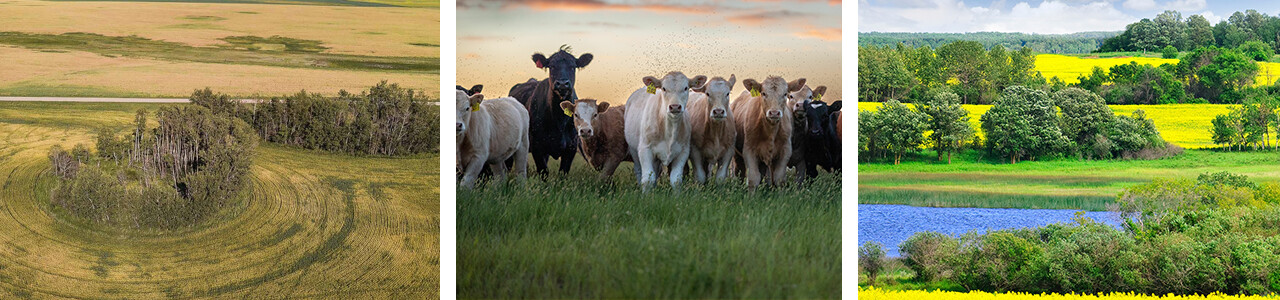
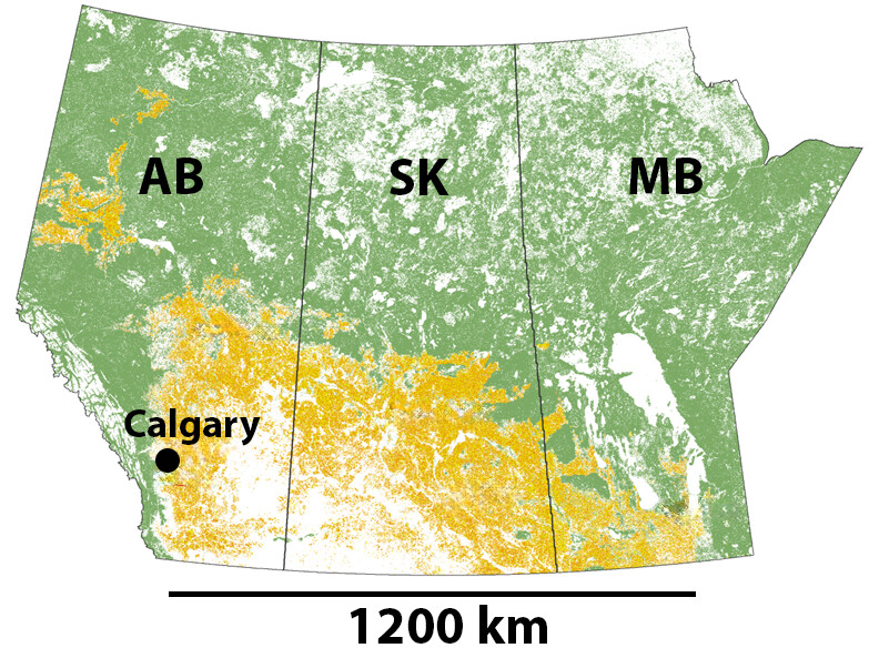
Our research is animated by the possibility that small changes to management in Canadian Prairie croplands (Figure 2) could lead to win-win-wins (i.e., mutually beneficial solutions for food production, biodiversity and climate).
For example, we could make fields messier, by restoring or retaining perennial non-crop vegetation (Figure 1; left and right). Patches of vegetation like these supply ecosystem services to agriculture, and serve as habitats for biodiversity, potentially improving crop yields in neighbouring fields.
Or, as our Prairie Precision Sustainability Network investigates, we can help farmers identify small parcels of low productivity marginal land that they can stop cultivating, increasing profitability, and creating new habitat and carbon sequestration opportunities when that land is restored in perennial plants.
Agrivoltaics is another exciting project in our lab. Co-locating cattle ranching with solar panels in small arrays (< 5 ha) helps to decarbonize our energy supply, and could have benefits for forage quality, soil health, and ecosystem services. In other words, maintaining food production while reducing impact.
Messy fields
Our lab has shown that “mess” (e.g., perennial and non-crop vegetation near crop fields) offers a measurable benefit by boosting yields [1–3], and by providing ecosystem services to crops. We found that these naturalized habitats host beneficial insects that move into the crop and supply services such as pest regulation, pollination and weed control (for more, see Biodiversity projects).
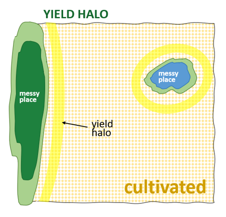
We have also reported that canola yield surrounding messy patches can be higher. We have called this the halo effect (Figure 3). It is small, and not usually visible to the eye, requiring analysis of data to show that it is present [2–4]. Its cause remains an open question, but it may depend, in part, on soil moisture, the type of adjacent vegetation, and the abundance of bees, beetles and other beneficials hosted there.
What’s next? We want to learn more about the halo effect. We’re just starting this journey. For example, how do moisture, vegetation type, patch size, arthropod ecosystem services, and soil fertility interact to create yield haloes? Wetlands and their vegetated margins are of particular interest. Can we value their contribution to crop yield as part of ecosystem service assessments?
Marginal areas
How can we make fields messier? Farmers may seed parts of their fields year after year and find that these acres, perhaps due to soil conditions, produce too little yield to offset their input costs (like the seeds, fertilizer, herbicides, etc.).
What if these areas were restored to perennial vegetation? Perenniality is a nature-based solution (NbS) for reducing greenhouse gases. When the land being converted is marginally profitable, it may may save the farmer money to stop seeding it. Messy places can also be habitats for biodiversity and supply many ecosystem services. Restoring marginal areas could therefore help rewild the Canadian Prairies while supporting climate objectives and (critically for implementation) improve the farmer’s bottom line.
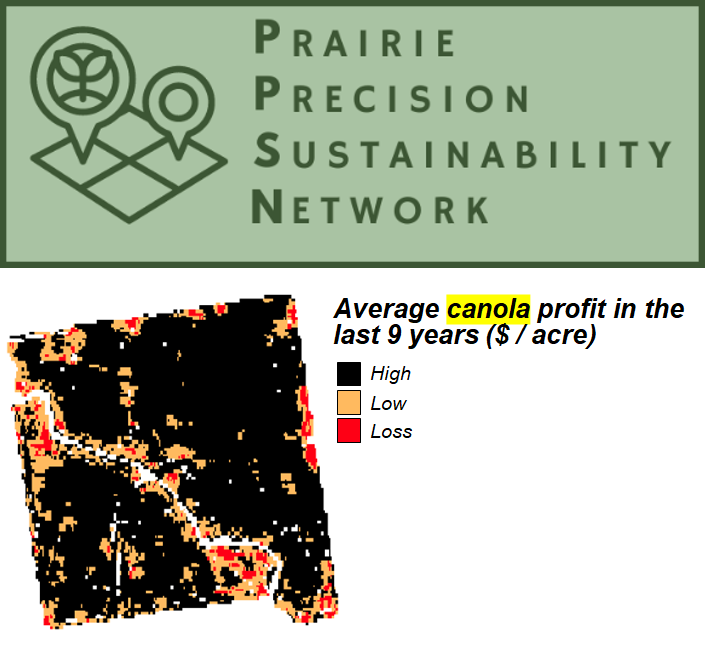
We’ve been working hard with our PPSN research network colleagues (Figure 4) to bring together precision yield, satellite imagery, and economic data to identify parts of fields that have multi-annual net-negative profitability. Thanks to data shared by over 70 farmers in Alberta, Saskatchewan and Manitoba, we’ve built a tool that farmers across the region can use to help them visualize the marginally-profitable parts of their fields.
What’s next? We’re going to work with farmers in the three prairie provinces to make fields messier (i.e., by restoring marginal areas to perennials). More on these exciting next steps very soon!
Agrivoltaics
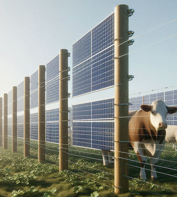
Working with Solartility we’re creating an Agrivoltaics Research Park at University of Calgary’s W.A. Ranches. It will occupy less than 10 ha of land, have bifacial upright panels, and cattle will graze beneath the panels. A distributed network of these small footprint facilities could go a long way to reducing the carbon exposure of the electrical grid. AI thinks the site will look something like this (Figure 5). We’ll have real pictures after the site is operating in 2025.
What’s next? The ABC Lab will lead the long-term environmental monitoring at this facility, researching the agricultural and environmental risks and benefits of constructing these facilities. Aligned with our agricultural sustainability theme, we will ask whether beef cattle agrivoltaics can be mutually beneficial for rancher livelihoods and for climate while minimizing impacts on the ranch environment.
Funders
We thank the following funders for their support of our agricultural sustainability research, since 2015 (in alphabetical order):
- Alberta Conservation Association
- Alberta Innovates
- Alberta Canola
- Ducks Unlimited Canada
- Environment and Climate Change Canada
- Manitoba Canola Growers
- Mitacs
- NSERC
- SaskCanola
- Solartility
Selected Publications from the lab
See more of our agricultural research publications here.
Keywords
agricultural landscape ecology; agricultural sustainability; agrivoltaics; agronomy; Canadian Prairies; ecosystem services; greenhouse gases; machine learning; perenniality; precision agriculture; remote sensing; rewilding.